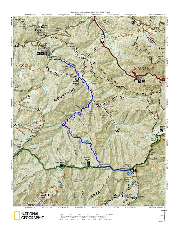
After an entire month of not accumulating any new miles in the park, the weather and my procrastination finally reached an accord enabling me to knock out the Goshen Prong Trail in a great hike from Clingmans Dome to Elkmont. 
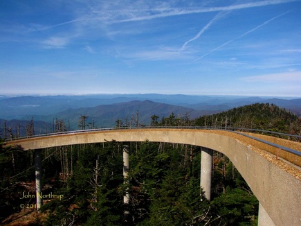
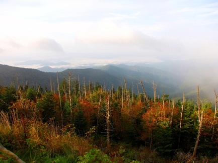
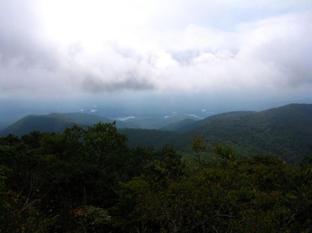
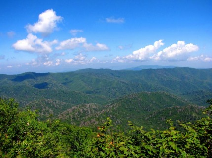
Temps at the Dome were in the 50's and the views were grand. 
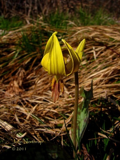
Despite the week's cool temps and heavy rains, even the Trout Lilies near the Dome were in fine shape. 
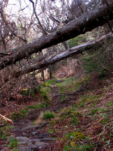
Not long after leaving the AT, the trail conditions got a little rough and rocky. 
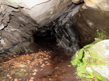
A vast cave in which one can crawl a ways into is situated just over halfway down from the AT to the campsite. 
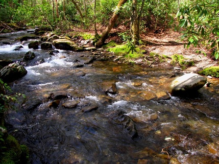
Where I was able to cross this unmentioned and unbridged stream crossing is somewhere at the top of the picture. 
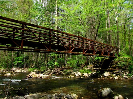
Taking a look at the mighty Goshen Gate Bridge over the Little River. 
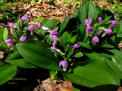
The clusters of Showy Orchis along the Little River Trail were the most impressive I've ever seen in the park anywhere.
3 Comments
Journal discussing 23.2 mile ridge walk from Clingmans Dome to High Rocks and back coming soon! Early fall morning with views from the Clingmans Dome parking lot. Some of the first reds of the season sported by the witch hobble. Heart leaved asters and erect goldenrod frequently lining the trail along Welch Ridge. Well crafted stair case leading up to the summit of High Rocks. Brief view down into Fontana Lake from bluffs of High Rocks. The park service cabin for the former High Rocks firetower withering away.
A change of pace can be a good thing. Yesterday I decided to scrap a hike and just relax in town. Sure, it slows my progress in terms of miles, but I'll find a way to get them in later on anyways. Today's hike would be one I had done before, but it was going to be extra special because I had somebody to share it with. My girlfriend, Bonnie, also on crew at LeConte, and I were able to coordinate our days off to get a hike in together. We've done several hikes up and around the mountain with our afternoons and evenings, but this was our first time to go elsewhere in the park, so we were very excited. We met at Clingmans Dome about mid-morning for a trek out to Silers Bald and back. Things looked promising from the get-go. For this summer being so scorching hot, we were both amazed at how clear views were all around. The skies were a rich blue, the mountains a lush green, and you could see for miles without the interference from haze. Since it was early in the day and we were so high in elevation, the way up the Dome Bypass Trail was nice and cool, a much appreciated break from the oppressive heat down below. I knew it wouldn't last much longer, so I enjoyed it as much as I could. After scaling Mt. Buckley, the tower at the dome was behind us and out of sight; thus, beginning our descent toward Silers Bald four and a half miles out. No matter which way you approach or depart Clingmans Dome, the trail is steep and rocky, unless it's the paved path up from the parking lot, in which case it's just steep. At least we had several vistas along this stretch that afforded views into both sides of the park. Again, we were astonished at how clear the views were for this time of year. What also makes this part of the hike so unique is that you are rarely in the typical fir forest for this elevation. Many of the slopes west of the dome are open fields of grasses, wildflowers, and blackberries. The first half of the hike saw a lot of filmy angelica, coneflower, white snakeroot, pink turtleheads, and goldenrod in bloom, especially in those open areas. You do eventually descend back into the forest and lose the impressive views, but you also swap the steep and rocky trail conditions for a flatter and muddier path. Finding detours around the little mud pits actually made for some fun. About halfway out you come to a clearing at Double Spring Gap which houses a backcountry shelter. When I was last here four years ago, it hadn't been renovated yet, but now it was and certainly looked more pleasing to the eye than that old raggedy chain link fence. What really brightened up the gap were the dense patches of coneflower, glowing in the late morning light. Of all the park's AT shelters, I think the one at Double Spring Gap has one of the better setting behind Mt. LeConte and Icewater Spring. In leaving the gap you make a climb up Jenkins Ridge. At one point we looked through the woods to our right and found a fenced enclosure. We weren't sure what it was at first, but when we looked around the ridge and saw all the devastation caused by those pesky wild hogs, it all made sense. Upon further inspection on our return trip, I saw that the park had sealed off a small area, similar to many of their beech enclosures to help protect the plants and wildlife from hog destruction. Pressing on, the surroundings continue to change. The ridge crest that the AT follows gets narrower and grassy, signs of the old balds that used to exist here. For this very reason, the stretch just east of Silers Bald is called The Narrows. They are entirely grown over at this point, but we both pondered how impressive the views would be here in the fall when the trees drop their foliage. As we got closer to our destination, you could catch glimpses through the trees of the steep climb that awaited us. Once you pass the junction with Welch Ridge, the trail wastes no time in heading up. Thankfully, it passed by quickly, and we were atop Silers Bald looking back at Clingmans Dome, impressed by the distance and drop in elevation we just covered. Hopefully the park at least maintains that view from the bald unlike the many others now forested over. Aside from the white blazes marking the AT, I followed a well trodden path to the north side of the bald that came out to a small rocky ledge. The view was fascinating as it overlooked the valley below of the Little River, with Mt. LeConte towering in the distance to the right, and the long spine of Miry Ridge, Dripping Spring Mountain, and Bent Arm Ridge to the left. And even now in the afternoon, the air was still clear. We ventured down the western slope of Silers Bald to scout for more views and ended up reaching the shelter for a snack break. The area around this shelter is much more closed in than that of Double Spring Gap. This point was our turnaround, so we headed back up and over Silers Bald. It would be all up to the dome, and now we were starting to get into the heat of the day. The views were just beginning to haze up as well, so at least our timing for the way out was spot on. We also began to see a lot of day hikers and backpackers. The heat really started to turn up when we began climbing Mt. Buckley, but luckily that meant we were close to the end. It's always a strange feeling when you make it to the dome and step off the AT, leaving solitude and serenity behind you, onto the paved, populated, and noisy trail to the tower. The views from the tower impeccable, as they always are on a clear day. We both look forward to our next outing together off the mountain, but it'll certainly be hard to beat this amazing day.
|
Thanks for visiting!I appreciate you stopping by. This site is for your enjoyment as much as it is mine. Look for new photos and journal entries about every 1-2 weeks. Archives
November 2011
Categories
All
|